“ I use this tool every day in my line of work. I can get accurate flood reports much quicker and easier than using other sites. ”
Jay Markas
Statewide Commercial Insurance

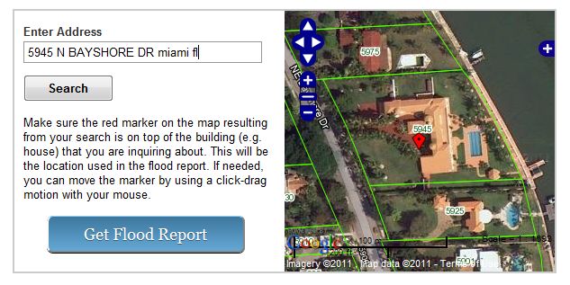
Find flood zone information by street address anywhere within Florida using our web-based Flood Zone Tool. If you are not in a flood zone, you can also view flood zone maps to determine if you are near one.
Our service is utilized by professionals in insurance, surveying, real estate, appraising, and engineering industries. Homeowners looking at their current or future property can also get accurate and up to date flood zone information.
You can access these tools via the web on both tablets and desktops. The Flood Zone Tool is also compatible with smartphones.
The flood report includes:
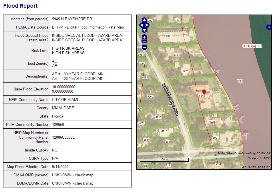
The MapWise GIS Map Viewer is an interactive mapping application that provides access to high resolution aerials, property boundaries, flood zones, wetlands, and more. It is included with a subscription to the Flood Zone Tool. More information is available on the GIS Map Viewer overview page.
Starting around 2000, FEMA has been updating flood zone maps around the country to a new version called Digital Flood Insurance Rate Map (DFIRM). In Florida, all counties have been updated.
Below is more information about flood zone maps.
| Zone | Description |
|---|---|
| V | 100-year floodplain with wave action, no BFEs determined. |
| VE | 100-year floodplain with wave action, with BFEs determined. |
| A | 100-year floodplain, no BFEs determined. |
| AE and A1-30 | 100-year floodplain, with BFEs determined. |
| AH | 100-year floodplain, with ponding, with BFEs determined. |
| AO | 100-year floodplain, with sheet flow, with BFEs determined. |
| AR | 100-year floodplain, previously protected by flood control structures and being restored. |
| A99 | 100-year floodplain, that will be protected by a flood control project under construction. |
| IN | 100-year floodplain, no BFEs determined. |
| B, X500 | 500-year floodplain (0.2% annual chance of flooding) |
| C, X | Outside 100-year and 500-year floodplain. |
| D, UNDES | Possible but undetermined flood hazards. |
| ANI | Area Not Included in any flood study. |
Table notes:
| Column | Description |
|---|---|
| FLD_ZONE | Flood Zone, e.g. A, AE, etc. |
| FLOODWAY | Floodway |
| SFHA_TF | IN or OUT of Special Flood Hazard Area (100 year flood zone) |
| STATIC_BFE | Base Flood Elevation |
| V_DATUM | Vertical Datum |
| DEPTH | BFE. The rounded, whole-foot elevation of the 1-percent-annual-chance flood. This is the value of the BFE that is printed next to the BFE line on the FIRM. |
| LEN_UNIT | BFE units, normally feet |
| VELOCITY | Velocity Measurement - n/a for Florida |
| VEL_UNIT | Unit of Measurement for Velocity |
| AR_REVERT | If the area is Zone AR, this field would hold the zone that the area would revert to if the AR zone were removed. |
| BFE_REVERT | If Zone is Zone AR, this field would hold the static base flood elevation for the reverted zone. |
| DEP_REVERT | If Zone is Zone AR, this field would hold that flood depth for the reverted zone. |
| SOURCE_CIT | Source Citation |
| ACRES | Acreage of flood zone polygon |
| COUNTY | County |
| FLOODPLAIN | Flood plain description |
| RISK_LEVEL | Insurance risk level |
| DESCRIPT | Code description |
| SOURCEDATE | Effective map date |
For more information and the definitive resource on Effective Map Dates, please refer to FEMA's Community Status Book Report
All plans include: