Property Details Report
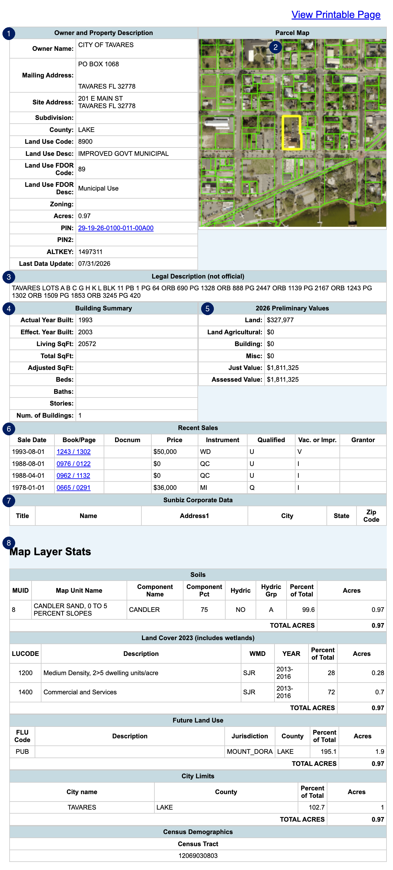
Property Details is MapWise's full report for a single parcel. Headed Property Appraiser Record, it gathers the owner, land use, assessment values, sales history, and map layer statistics for one property, built from county property appraiser data. Open it with the Property Details link on any search-result row or selected parcel.
How do I open the Property Details report?
- From search results: run a Parcel Search, then click Property Details on any row of the results grid.
- From the map: select parcels with the Select Parcels tool. Each parcel listed in the left panel includes its own Property Details link.
- From a single parcel: use Identify Parcel (the i-tool) to open a parcel in the left Parcel Info tab, then click More Property Details.
- Either way, the report opens in the Property Details tab of the main panel, headed Property Appraiser Record.
You should now see the Property Appraiser Record for your parcel in the Property Details tab.
What is in the report?
Top to bottom, the report covers:
- Owner and Property Description: owner name and mailing address, site address, subdivision, county, land use codes and descriptions (county and FDOR), zoning, acres, and the parcel identifiers (PIN, PIN2, ALTKEY). Where MapWise has a matching link, the PIN links straight to the parcel's page on the county property appraiser's website. A Last Data Update field shows when MapWise last refreshed the county data behind the record.
- Parcel Map: a snapshot of the parcel outlined on the map.
- Legal Description (not official): the property appraiser's recorded legal description.
- Building Summary: building details for improved parcels.
- Values: assessment values by tax year, labeled Preliminary or Certified.
- Recent Sales: recent transactions with price, date, qualification, vacant/improved status, and grantor.
- Sunbiz Corporate Data: corporate registration details for company-owned parcels, matched against Florida's Sunbiz registry.
- Map Layer Stats: GIS overlays computed for this parcel: Soils, Land Cover (including wetlands), Future Land Use, City Limits, and Census Demographics.
How do I print the report?

- Click View Printable Page at the top right of the report. A printer-friendly copy opens in a new browser tab.
- Print it with your browser's print command (Ctrl+P on Windows, Cmd+P on Mac).
The report itself has no export button. To save parcel data as a file, export from the Search Results grid instead. See Manage & Export Results.
Frequently Asked Questions
How do I see the full property record for a parcel in MapWise?
Run a Parcel Search and click Property Details on any results row, select parcels on the map and click a parcel's Property Details link in the left panel, or identify a parcel with the i-tool and click More Property Details on the Parcel Info tab. The report opens in the Property Details tab, headed Property Appraiser Record, with owner, values, sales history, and map layer stats.
Can I print the Property Details report?
Yes. Click View Printable Page at the top right of the report to open a printer-friendly copy in a new browser tab, then use your browser's print command. To save parcel data as a file instead, export from the Search Results grid.
Where does the Property Details data come from?
The report is built from county property appraiser records, supplemented with MapWise GIS layers such as soils, land cover, future land use, and census demographics. The Last Data Update field near the top shows when MapWise last refreshed the county data behind the record.
Ready to Get Started?
Select a plan, schedule a personalized demo, or contact our support team.