FEMA Flood Zones DFIRM
About the FEMA Flood Zones DFIRM Layer
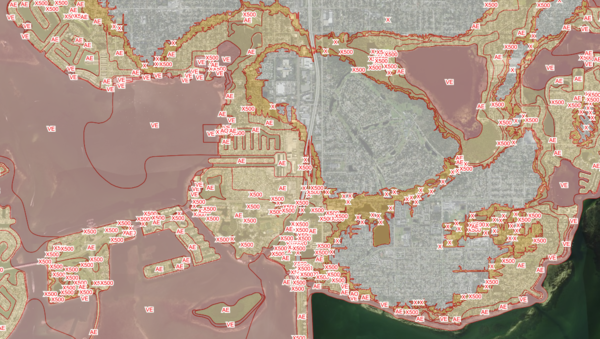
The FEMA Flood Zones layer maps the official flood risk designations every property owner, lender, and insurer in Florida lives with. Each polygon on the map is a zone from the Flood Insurance Rate Map, known as the FIRM, the legal record FEMA maintains to determine which properties sit in the 100-year floodplain, the 500-year floodplain, or outside any mapped flood hazard.
Zones fall into three broad categories. Special Flood Hazard Areas (A, AE, AH, AO, V, VE) carry a one-percent chance of flooding in any given year, and properties with federally backed mortgages inside them are required to carry flood insurance. Moderate risk zones (shaded X, also labelled X500) face a 0.2-percent annual chance of flooding. Unshaded X zones are outside any mapped flood hazard. Where base flood elevations have been modelled, they are shown so owners can compare finished floor elevation against the regulatory benchmark.
Who uses this layer
Mortgage lenders check it on every purchase or refinance to enforce the federal flood insurance purchase requirement. Property insurers price flood policies against the zone, floodway, and base flood elevation. Real estate agents and title companies flag flood risk on listings and in flood determination letters. Civil engineers and surveyors reference it during site design, grading, and elevation certificates. Floodplain managers at cities and counties enforce building and mitigation requirements inside the mapped floodplain. Emergency managers use it to plan evacuations and estimate exposure during tropical storms and hurricanes.
Coverage and accuracy
The layer covers every Florida county for which FEMA has published a Digital Flood Insurance Rate Map. Polygon edges are drawn from FEMA modelling at a source scale of 1:12,000, with horizontal accuracy of approximately plus or minus 38 feet. FEMA updates individual panels on a multi-year cycle as new studies are completed, and amendments through Letters of Map Amendment and Letters of Map Revision can re-draw boundaries between major updates. Always check the current effective FIRM with FEMA or your local floodplain administrator before relying on the zone for a legal determination.
Layer Details
- Layer Group
- Flood Zones
About the Data
- Data Source
- FEMA
- Time Period
- 2026-03-24
- Update Frequency
- As needed for updates
If not, please contact us and we'll gladly help you further.
