Soils Hydric
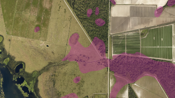
About the Soils Hydric Layer
Soil is the foundation of everything built on, grown on, or drained across Florida, and the Soils SSURGO layer is the most detailed statewide picture of what is under the surface. Every soil polygon on the map represents a distinct soil type with known physical and chemical properties, and each polygon is tied to a rich table of attributes that describe how that soil behaves.
The data comes from decades of fieldwork by the Natural Resource Conservation Service, a federal agency whose soil scientists walked, augered, and sampled every county in Florida to map soil boundaries at a scale of one inch to 2,000 feet. MapWise uses a simplified view of that database so the most useful facts are easy to see at a glance: soil series name, texture, drainage class, hydric rating, depth to bedrock, flooding frequency, farmland classification, and engineering ratings for roads.
Who uses this layer
Farmers, nurseries, and agricultural lenders use soils to judge productivity and irrigation needs before leasing or purchasing land. Environmental consultants check hydric ratings during wetland delineations and permitting. Civil engineers and septic designers read drainage class and bedrock depth to plan foundations, roadbeds, stormwater systems, and on-site sewage treatment. Real estate professionals and appraisers cross-reference soils with flood and wetland layers to understand development limits on rural or waterfront tracts. Conservation groups and land trusts use soils to prioritize acquisition targets and to document agricultural value for easements.
Coverage and accuracy
The layer covers 52 Florida counties, which together include almost all of the state's agricultural and developable land. Boundaries are accurate to roughly 40 feet, which is appropriate for planning and screening decisions but not for site-specific work like septic drainfield layout. For any decision that turns on soil conditions at a single point, a site-specific soil test by a licensed professional remains the authoritative answer. SSURGO boundaries are updated occasionally by NRCS as new surveys are completed.
Layer Details
- Visible Scale Range
- 1:423 to 1:100K
- Layer Group
- Soils
About the Data
- Data Source
- Natural Resources Conservation Service
- Publish Date
- 2012
- Time Period
- 2012-01-01
- Horizontal Accuracy
- +/- 40 feet
- Source Scale
- 24000
If not, please contact us and we'll gladly help you further.
