Wetlands NWI
About the Wetlands NWI Layer
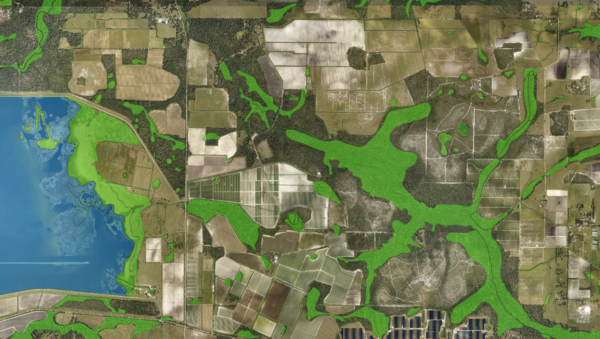
The National Wetlands Inventory layer is the most widely used reference map of wetlands and surface water in Florida. Produced by the US Fish and Wildlife Service, it shows estuarine and marine wetlands, freshwater marshes, forested swamps, ponds, lakes, and rivers, classified using the Cowardin system that is the national standard for wetland mapping.
Each polygon on the map carries a full classification: the hydrologic system (estuarine, palustrine, lacustrine, riverine, or marine), the dominant vegetation or bottom type, the water regime, water chemistry, soil category, and any special modifier such as impoundment, ditch, or partial drainage. The attribute codes follow the structure Cowardin and colleagues set out in 1979 and that the Service has applied and refined for more than four decades.
Who uses this layer
Environmental consultants and wetland scientists use the National Wetlands Inventory as the starting point for preliminary delineations and for scoping the wetland presence on any site before a field visit. Developers and site planners screen parcels early in feasibility work to identify potential wetland impacts and mitigation exposure. Conservation organizations and land trusts track habitat extent, prioritize acquisitions, and monitor change. Water resource and fisheries agencies use it to map habitat. Floodplain managers and stormwater planners reference it alongside soils and FEMA flood zones for watershed and drainage planning. Real estate buyers of rural and waterfront property cross-reference it with parcel boundaries to understand what portion of a tract is likely unbuildable.
Coverage and accuracy
The layer covers the entire state of Florida, with mapping at a source scale of 1:24,000 and horizontal accuracy of approximately plus or minus 40 feet or more depending on the age of the source photography. Aerial photo dates vary widely across the state, from the 1970s in parts of interior north Florida to the 2010s and 2020s in south Florida, coastal Florida, and the Panhandle. Because boundaries are photo-interpreted rather than field-surveyed, the National Wetlands Inventory does not represent jurisdictional wetlands under the Clean Water Act. For permitting decisions, a formal delineation by a qualified wetland scientist and concurrence from the US Army Corps of Engineers and the Florida Department of Environmental Protection remain the authoritative sources.
Layer Details
- Layer Group
- Land Cover
About the Data
- Data Source
- US Fish and Wildlife Service
- Publish Date
- 12/7/2022
- Time Period
- 2014-10-01
If not, please contact us and we'll gladly help you further.
