Land Cover 2023
About the Land Cover 2023 Layer
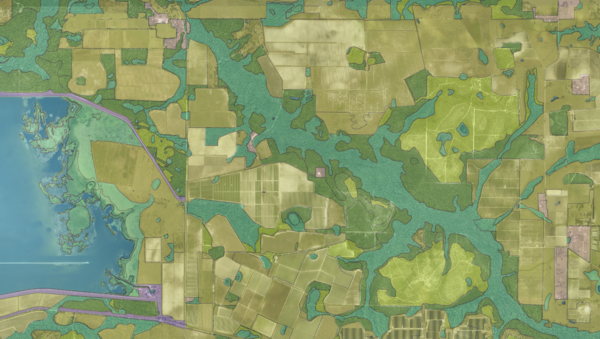
The Land Cover 2023 layer shows how the ground is actually being used across every acre of Florida. Each polygon is coded with what is present on the surface today, ranging from urban residential and commercial to row crops, improved pasture, pine plantation, natural upland forest, freshwater marsh, saltwater marsh, mangrove swamp, open water, and dozens of more specific classes in between.
The underlying data was produced by Florida's five Water Management Districts and compiled into a single statewide dataset by the Florida Department of Environmental Protection. Each District mapped its own territory using recent aerial photography and a shared classification system known as FLUCCS, so codes mean the same thing whether the polygon sits in the Panhandle or the Everglades. The layer identifies which District produced each polygon, which year it was mapped, and gives both the detailed four-digit code and a rolled-up parent category for quick filtering.
Who uses this layer
Environmental scientists and water quality modelers use land cover as a primary input for runoff, pollutant loading, and groundwater recharge calculations. Conservation organizations track natural habitat extent and identify fragmentation over time. Agricultural lenders and crop insurers verify current use on rural parcels. Developers and site planners use it early in feasibility work to estimate clearing costs, wetland presence, and mitigation exposure before ordering a formal assessment. Local government planners and utilities reference it for capacity and service planning. Researchers and graduate students use the time series to study land use change, urbanization, and ecosystem conversion.
Coverage and accuracy
The layer spans the entire state of Florida. Mapping scale is approximately one inch to 1,000 feet, with polygon boundaries accurate to roughly 23 feet. Map dates vary by District, from 2013 in parts of the St Johns basin to 2022 in the Panhandle, so older regions may not reflect recent development. For regulatory decisions such as wetland jurisdiction, always confirm with the relevant agency and a field assessment.
Layer Details
- Layer Group
- Land Cover
About the Data
- Data Source
- Florida Water Management Districts, FDEP
- Publisher
- FDEP
- Publish Date
- 2024-03-07
- Time Period
- 2024-03-07
- Update Frequency
- irregular
- Horizontal Accuracy
- Approximately +/- 23 feet
- Source Scale
- 12000
If not, please contact us and we'll gladly help you further.
